


Optimizing technicians’ schedules and routes in bluebee® with GeoConcept
This month’s partner article features GIS supplier GeoConcept, which provides embedded GIS components for bluebee® cloud and bluebee®. The article focuses more particularly on scheduling and optimization tools available for bluebee® cloud, thanks to the specific GIS expertise offered by Value Added Partner GeoConcept.
bluebee® cloud maps and GIS extension
Siveco’s bluebee® cloud offers geographical navigation through maps: users can zoom, click on a specific site, access to corresponding data, view related KPIs, etc.
Through the use of widgets, bluebee® cloud can integrate web mapping services such as Googles Map or Baidu Maps, to display objects on a map. The map widget, embedded in a user dashboard, can also be expanded full-screen (for example for display on a large screen in a control center).
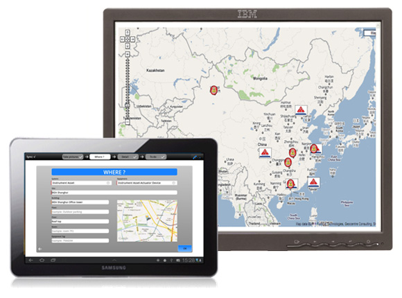
For more advanced geographical functionality, i.e. full Geographical Information System (GIS) capability, bluebee® cloud provides a GIS extension module with its own GIS (the embedded version of GeoConcept GIS) with various options. Alternatively, bluebee® cloud can integrate with third-party GIS, either open source or commercial products.
About GeoConcept Group
GeoConcept Group (www.geoconcept.com) is Europe’s leading Geographical Information System publisher and ranks among the world leaders in mapping and optimization application for business. Always at the cutting-edge, GeoConcept Group is the only “designer” of innovative solutions aiming to bring about a profound improvement in companies’ and organisations’ efficiency. By combining geographical information with optimisation tools, GeoConcept Group invented geoptimisation, optimising activities by intelligently integrating systems with geographical information. The benefits of geoptimisation apply to areas as varied as geo-marketing, routing & scheduling, territory management and crisis management.
GeoConcept Group has enjoyed sustained growth ever since its creation and continues to expand internationally by means of a direct presence in a number of strategic countries such as Spain, Switzerland, Japan, China, India, and more recently Comlubia. GeoConcept solutions are available in 7 languages. Today, GeoConcept Group numbers more than 10,000 client references and boasts an installed base of more than 105,000 licences in 30 countries.
GeoConcept Group is a Siveco VAPP partner (more on the Value Added Partner Program): GeoConcept GIS technology is embedded in bluebee® cloud and bluebee® as part of the GIS extension module; GeoConcept also provides specialist services when needed for Siveco implementation projects. Joint customers include major field service and infrastructure companies such as EDF (French State Power) or GDF Suez (the world’s largest private utility) and many of its subsidiaries.
Opti-Time GeoScheduling Suite (GSS) by GeoConcept
For large distributed organizations, such as municipal infrastructures or maintenance service companies, taking better account of geographical realities can reduce customer service staff travelling time by 20%: a shorter customer service response time, a commitment to the customer and higher productivity. Geography helps you to qualify what you do and define the best possible deployment of one’s resources on the ground to cover the market as a whole. By taking account of numerous constraints (technical expertise, experience, geographical proximity, availability, equipment/vehicle capability, specific site characteristics…), optimisation solutions enable you to send the right technician, at the right time to the right place and at the minimum cost. Embedded in the bluebee® cloud platform and making full use of mobile deployments, where technicians are equipped with bluebee® “for the worker of tomorrow“
The Opti-Time GeoScheduling Suite (GSS) is a scheduling optimisation software suite which manages appointment, customer service and delivery schedules. From booking appointments to optimising movements on the ground via the definition and consideration of all the business and sectoral constraints, the Opti-Time GSS provides mobility decision-makers and operational staff with a comprehensive and customised solution. Whatever the constraints might be, the software suite minimises the mileage clocked up by each operator and the amount of time spent in the vehicle to establish perfectly efficient geo-optimised schedules targeted, relevant, rapid and cheaper customer service callouts.
Activities are continuously optimised thanks to a centralised architecture : real-time management of appointments, insertion of new events, updating schedules, managing emergencies… activities are fully modelled for optimal efficiency: in addition to geographical optimisation (calculating routes), customer constraints, resources and expertise are managed as well.
Moreover, use of the most up-to-date communication technologies, making it possible to extend information publishing and exchange capabilities using bluebee® mobile solution: real time data-entry and uploading of field information, dynamic integration of rounds on bluebee®
Main features
– Optimising appointments and rounds
– Schedule management
– Activity modeling (time and competences)
– Booking appointments inbound and outbound
– Rules and definitions tailored to the business
– Connection with GPS (from bluebee®)
– Schedule management
– Activity modeling (time and competences)
– Booking appointments inbound and outbound
– Rules and definitions tailored to the business
– Connection with GPS (from bluebee®)
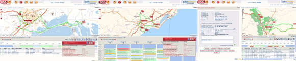
Example of Opti-Time GSS screenshots:
Architecture
The Opti-Time GeoScheduling Suite is an optional module part of bluebee® cloud GIS extension. The suite includes the following components:
– Geographical services such as geocoding and calculating routes
– Optimisation components including the optimisation engine
– A web-type interface embedded in the bluebee® cloud portal
– The centralized bluebee® cloud database enabling the immediate sharing of information
– Very accurate and very comprehensive cartographic data provided by Navteq
– An administration module for day-to-day management of the application
– A supervision module for monitoring and steering activity
VAPP at its best
For large field service organizations, a reduction of 20% of traveling time can be obtained, together with the corresponding improvement in response time and quality of service. The Opti-Time GeoScheduling Suite (GSS) provides the necessary tools, fully embedded in bluebee® cloud, thanks to the openness of the Siveco software solution. Whenever required for complex optimization or integration cases, GeoConcept GIS experts also work alongside the Siveco project team, to deliver more value to our customers!
For more information on bluebee® cloud’s Opti-Time GeoScheduling Suite (GSS) by GeoConcept and its possible application to your business needs, contact us at info@sivecochina.com.